“VEIA DI SCUETAR”, LA VIA DEGLI SCOIATTOLI
Valle Antigorio
Routenbeschreibung
JAHRESZEIT von Mai bis Oktober
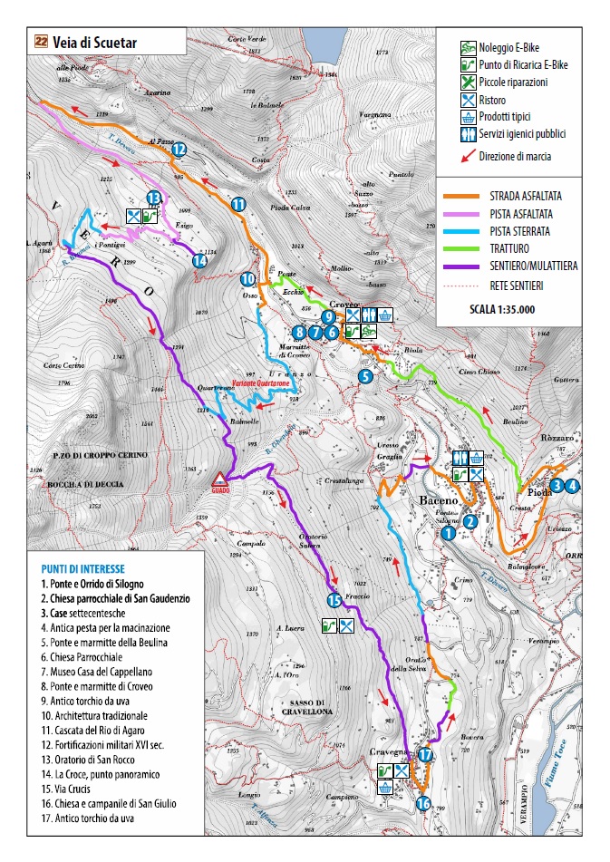
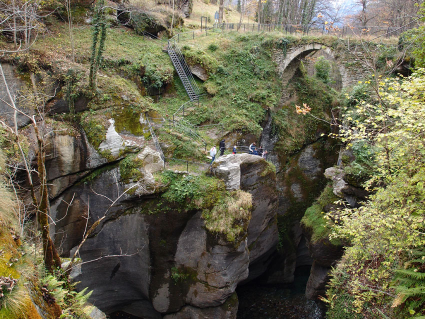
Man fährt von Baceno an der Hauptstraße entlang nach Croveo hinauf. Hinter der Pfarrkirche von Croveo nimmt man den Saumpfad zur Brücke der Strudeltöpfe von Croveo, erstaunlichen Formen der Erosion mit einem Aussichtspunkt. Am Ende der Brücke biegt man rechts nach Osso ab und fährt weiter auf der Landstraße bis kurz vor Goglio, wo bei einer Beton-Bogenbrücke die für den normalen Verkehr gesperrte landwirtschaftliche Piste beginnt, die nach Esigo ansteigt, weiter hinauf zum Ferien-Bauernhaus Ca’t Fausc führt und anschließend Pontigei und Agarù erreicht. Hier verlässt man die Piste, die in das Bondolero-Tal ansteigt und biegt nach Cravegna ab, auf die so genannte Via di Squettar (Eichhörnchenweg), einem Wanderweg auf halbem Hang der fast immer breit ist, aber vor allem an den Tälern schmaler und kaum befahrbar wird. Der letzte Abschnitt des Saumpfads ist eine wunderschöne Via Crucis mit großen Stufen, über die man schließlich Cravegna erreicht. Von dem Dorf aus folgt man der Straße die talwärts führt bis zur Kehre nach dem Oratorium Selva, wo man einen Saumpfad einschlägt, der zum hohen Teil von Crino führt. Hier beginnt eine ebene Piste, die fast bis nach Graglia führt. Sobald man auf die asphaltierte Straße stößt, folgt man dieser für drei Kehren und fährt das letzte Stück auf einem steilen Saumpfad zum Sportplatz von Baceno hinunter und bis zum Rathausplatz.
AUTOR Alessandro Pirocchi
Zurück zur Routenliste
Parmi Baceno, Esigo et Cravegna
“VEIA DI SCUETAR”, LA VIA DEGLI SCOIATTOLI
Valle Antigorio
Routenbeschreibung
SAISON De mai à octobre
On part de Baceno et on remonte la route provinciale jusqu’à Croveo. Derrière l’église paroissiale de Croveo, on s’engage sur le chemin muletier qui mène au pont des marmites de Croveo, de spectaculaires formes d’érosion avec un point d’observation. Au bout du pont, on tourne à droite en direction d’Osso puis on continue sur la route provinciale et peu avant Goglio, au niveau d’un pont en béton arqué, on prend la route consortiale réservée aux personnes autorisées, qui monte jusqu’à Esigo, et jusqu’au gîte rural Ca’t Fausc avant de rejoindre Pontigei et Agarù. Ici, on quitte la piste consortiale qui remonte la Val Bondolero et on prend la direction de Creavegna en suivant la soi-disant Via di Squettar (Route des Écureuils) un grand sentier à mi-côte assez large mais qui se resserre par endroits surtout au niveau des vallons, devenant peu cyclable. Le dernier tronçon du chemin muletier est un très beau Chemin de Croix en escalier, puis on rejoint Cravegna. Au village, on suit la route qui descend vers la vallée jusqu’au tournant après l’oratoire de la Selva, où on s’engage sur un chemin muletier qui rejoint les hauteurs de Crino. Ici commence une piste de terre sans dénivelés qui mène pratiquement à Graglia. On croise la route goudronnée, on suit trois tournants et on descend en empruntant un dernier tronçon d’un chemin muletier escarpé jusqu’au stade de Baceno puis jusqu’à la place centrale de la mairie.
AUTEUR Alessandro Pirocchi
Zurück zur Routenliste
Between Baceno, Esigo and Cravegna
“VEIA DI SCUETAR”, LA VIA DEGLI SCOIATTOLI
Valle Antigorio
Routenbeschreibung
SEASON From May to October
You start from Baceno and climb to Croveo along the provincial road. Behind the parish church of Croveo you take a mule track which leads to the bridge of the potholes of Croveo, spectacular forms of erosion where there is an observation point. At the end of the bridge you turn right for Osso and from here you continue on the provincial road until shortly before Goglio where, at a cement arch bridge, part of the farm road passable only by farmers and which climbs to Esigo, then Ca’t Fausc holiday farm and finally reaches Pontigei and Agaru. From here you leave the farm track that climbs to Val Bondolero and set off for Cravegna taking the so-called Via di Scuetar (Road of the Squirrels) a track halfway up the slope which is normally wide but some stretches, especially in the ravines, are narrower and little cycling can be done. The last stretch of mule track is a beautiful Via Crucis (Way of the Cross) with steps and finally you come to Cravegna. From the village you follow the road that goes down toward the bottom of the valley to the hairpin bend after the Selva oratory where you take mule track that arrives at the top part of Crino. A flat unmade track starts here and leads almost to Graglia. When you arrive at the tarmac road follow it for three hairpin bends and in the last stretch you go down a steep mule track to the sports field in Baceno and then to the central square of the town.
Hotel Edelweiss
Viceno, 7 – 28862 Crodo (VB)
Tel. +39 0324618791
www.albergoedelweiss.com
AUTHOR Alessandro Pirocchi
Zurück zur Routenliste

