GIRO D’ITALIA: MACUGNAGA
Valle Anzasca
Routenbeschreibung
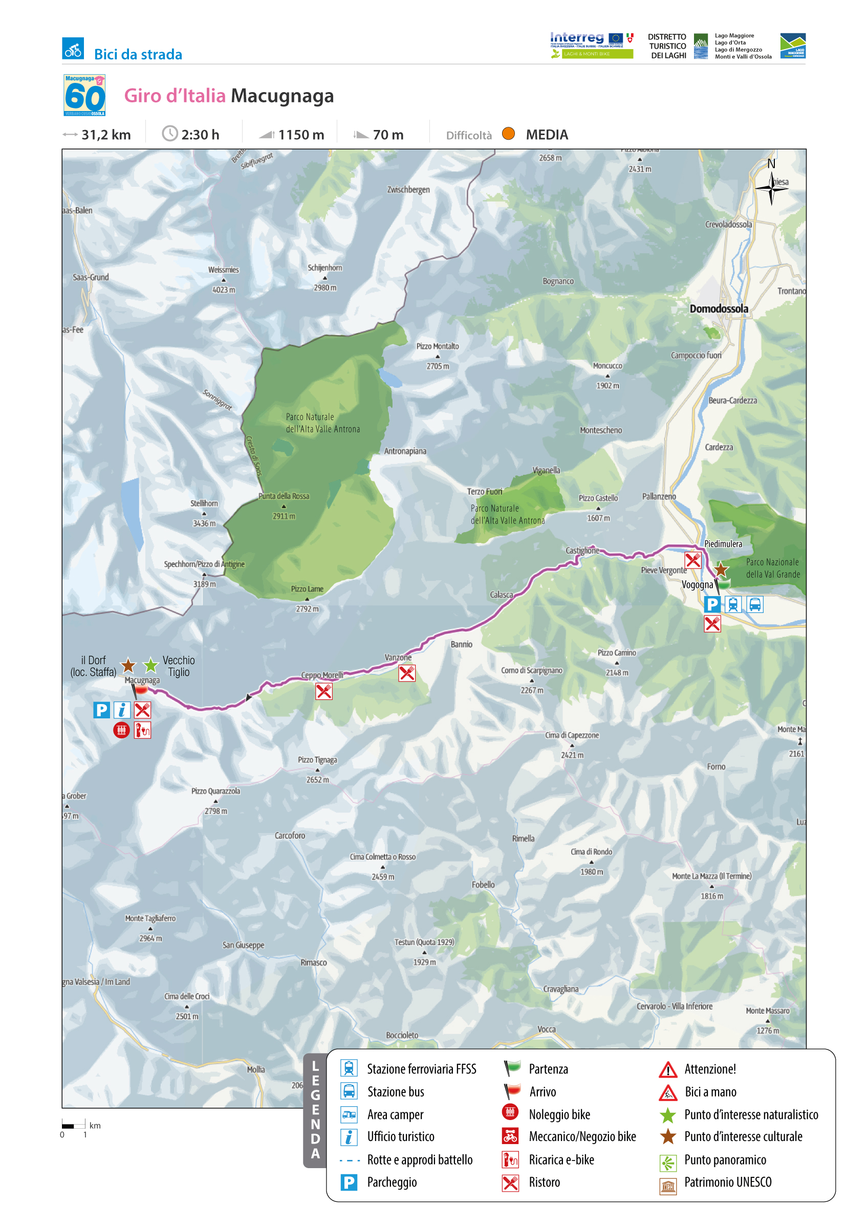
Der Anstieg am Fuße des majestätischen Monte Rosa beginnt in Vogogna, der alten Hauptstadt des unteren Ossola-Tals, die vom Visconti-Schloss dominiert wird und Sitz des Nationalparks Val Grande ist.
Kurz nach dem Start am Rathaus von Vogogna trifft man auf ein interessantes historisches Zeugnis: ein Felsen und eine Stele mit einem Adler, der von der Präsenz eines römischen Grabsteins aus 196 n. Chr. zeugt und an Geo Chavez erinnert, der als erstes die Alpen überflog.
Es folgt eine doppelte Kurve, eine Unterführung der Eisenbahn mit einer Linkskurve auf der Masone-Brücke über den Fluss Toce aus dem Jahr 1810.
Nach einer Autobahnunterführung und einem Kreisverkehr geht es an der zweiten Ausfahrt in Richtung Piedimulera und nach einem weiteren Kreisverkehr geradeaus entlang des Torrente Anza weiter, nachdem das Valle Anzasca benannt ist, bis man den Beginn der eigentlichen
Steigung nach Macugnaga erreicht.
Zurück zur Routenliste
GIRO D’ITALIA: MACUGNAGA
Valle Anzasca
Routenbeschreibung
La montée au pied de sa majesté le Monte Rosa commence à Vogogna, l’ancienne capitale du Val d’Ossola inférieur surmontée par le Château de la famille Visconti qui accueille le siège de l’Organisme de gestion du Parc National du Val Grande.
L’itinéraire part de l’Hôtel de Ville de Vogogna, peu après, vous verrez un témoignage historique intéressant : au pied de la colonne, surmontée d’un aigle, en l’honneur de Geo Chavez, le premier aviateur à survoler les Alpes, se trouve une plaque romaine qui atteste la construction de la route du Val d’Ossola en l’an 196 après J.C.
Après deux courbes, empruntez le passage sous le pont ferroviaire puis tournez à gauche sur le pont de la Masone qui date 1810 et enjambe la rivière Toce.
Ensuite passez sous l’autoroute puis, au rond-point, prenez la deuxième sortie vers Piedimulera; au rond-point suivant, continuez tout droit et longez le torrent Anza, qui donne son nom à la Vallée Anzasca, jusqu’au commencement de la montée, pour Macugnaga.
Zurück zur Routenliste
GIRO D’ITALIA: MACUGNAGA
Valle Anzasca
Routenbeschreibung
The ascent to the foot of His Majesty Monte Rosa begins in Vogogna, the ancient capital of the Ossola Inferiore overlooked by the Visconti castle and where the Val Grande National Park Authority is headquartered.
Shortly after departing from the Vogogna Town Hall, one encounters an interesting historical relic: a rock and a stele complete with an eagle that testifies to the presence of a Roman tombstone from 196 AD and the memory of Geo Chavez, the first transfer of the Alps.
Next, there is a double-curve railway underpass with a left turn onto the Masone Bridge over the Toce River, dated 1810.
Highway underpass, traffic circle, second exit towards Piedimulera, another traffic circle, then straight ahead following the course of the Anza stream, which gives its name to the Anzasca Valley, until you reach the foot of the climb proper, reaching Macugnaga, the “Pearl of Monte Rosa”.
Zurück zur Routenliste
GIRO D’ITALIA: MACUGNAGA
Valle Anzasca
Routenbeschreibung
La salita ai piedi di sua maestà il Monte Rosa inizia da Vogogna, l’antica capitale dell’Ossola Inferiore su cui domina il castello Visconteo e dove ha sede l’Ente Parco Nazionale della Val Grande.
Poco dopo la partenza dal Municipio di Vogogna s’incontra un’interessante testimonianza storica: una roccia e una stele con tanto di aquila che testimoniano la presenza di una lapide romana del 196 d.C. e il ricordo di Geo Chavez, il primo trasvolatore delle Alpi.
A seguire, doppia curva, sottopasso ferroviario con svolta a sx sul ponte della Masone sul fiume Toce, datato 1810. Sottopasso autostradale, rotonda, seconda uscita verso Piedimulera, altra rotonda, poi via diritti seguendo il corso del torrente Anza, che dà il nome alla Valle Anzasca, sino a giungere ai piedi della salita vera e propria, che condurrà a Macugnaga, la “Perla del Rosa”.
Zurück zur Routenliste

