Längere Wanderung auf einem halben Rundweg durch dichte Wälder und eindrucksvolle verlassene Dörfer
CANNOBIO – MONTE GIOVE
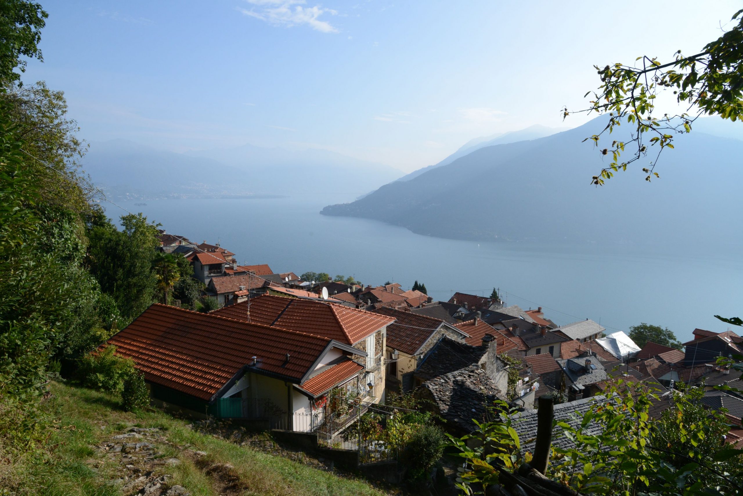
Lago Maggiore
Routenbeschreibung
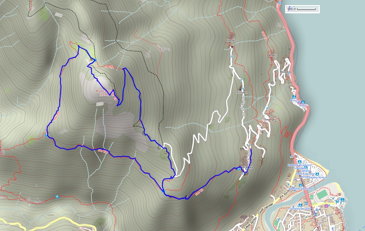
Ausgangsort: Sant’Agata di Cannobio (450 m)
Zielort: Monte Giove (1298 m)
Höhenunterschied: 850 m insgesamt
Entfernung: 9 km insgesamt
Wanderzeit ohne Pausen: 4 Stunden und 30 Minuten insgesamt
Art der Wege: gemischt (Wanderweg, asphaltierte Straße, Waldweg)
Wegweiser: weiß-rote Schilder „Monte Giove“; weiß-rote Markierungen; Schilder „Biessen“ und „Sant’Agata“; alte gelb-rote Markierungen
Wasser: Brunnen in Sant’Agata
Empfohlene Jahreszeit: ganzjährig, wenn kein Schnee liegt
Wie man hinkommt: der Ort ist 38 km entfernt von Gravellona Toce. Hauptstraße SS34 Richtung Verbania/Locarno. Nach der Ortschaft Cannobio biegt man nach links ab, in Richtung Ronco und Sant’Agata. Großer Parkplatz auf der linken Seite kurz vor dem Ort. Mit dem Bus: Linie 17 Cannobio–Sant’Agata (www.vcotrasporti.it).
Informationen: Distretto Turistico dei Laghi www.distrettolaghi.it; Fremdenverkehrsbüro IAT – Largo alla Chiesa 3, im Palazzo Parasio, Cannobio www.procannobio.it; Gemeinde Cannobio www.comune.cannobio.vb.it
Die Tour
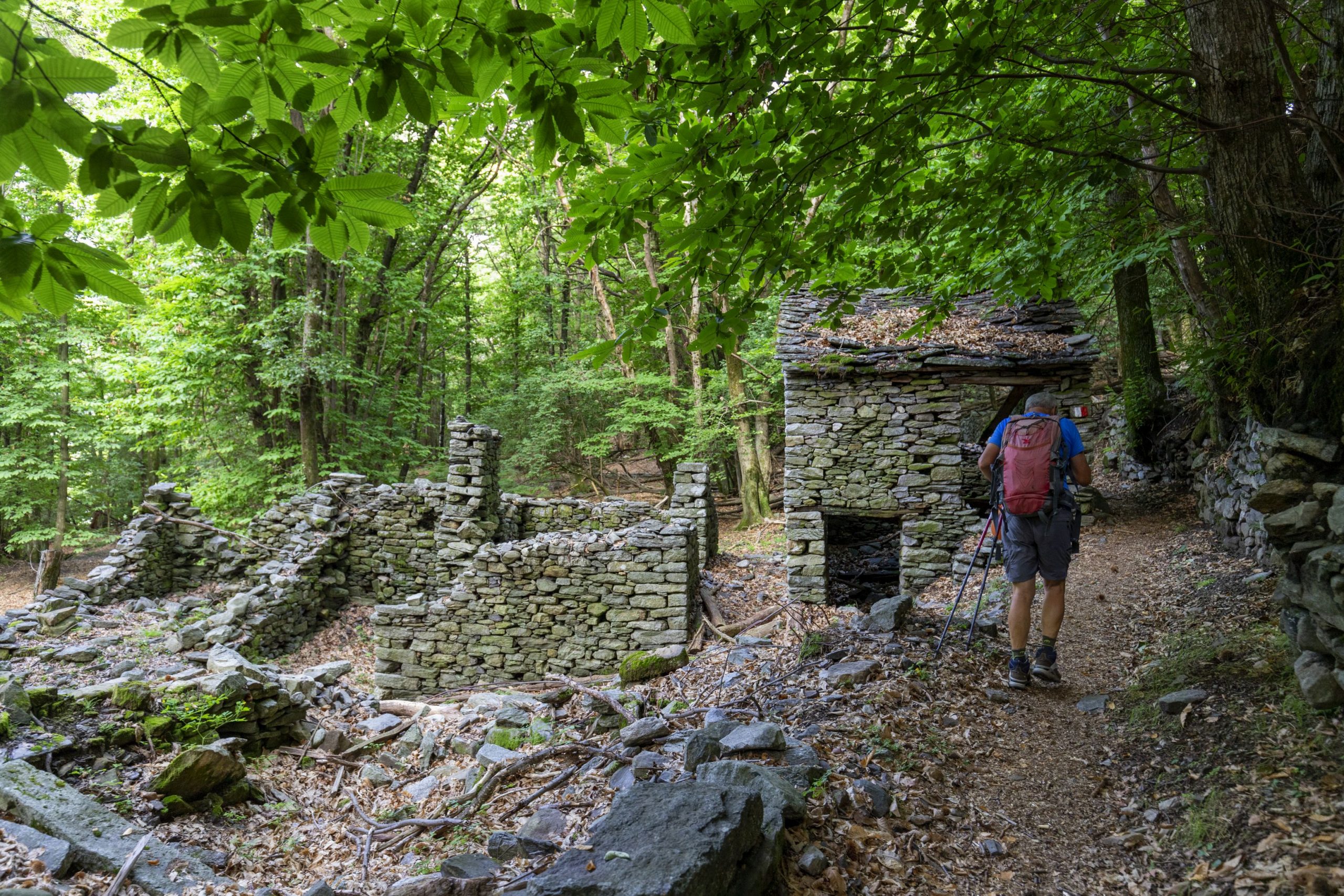
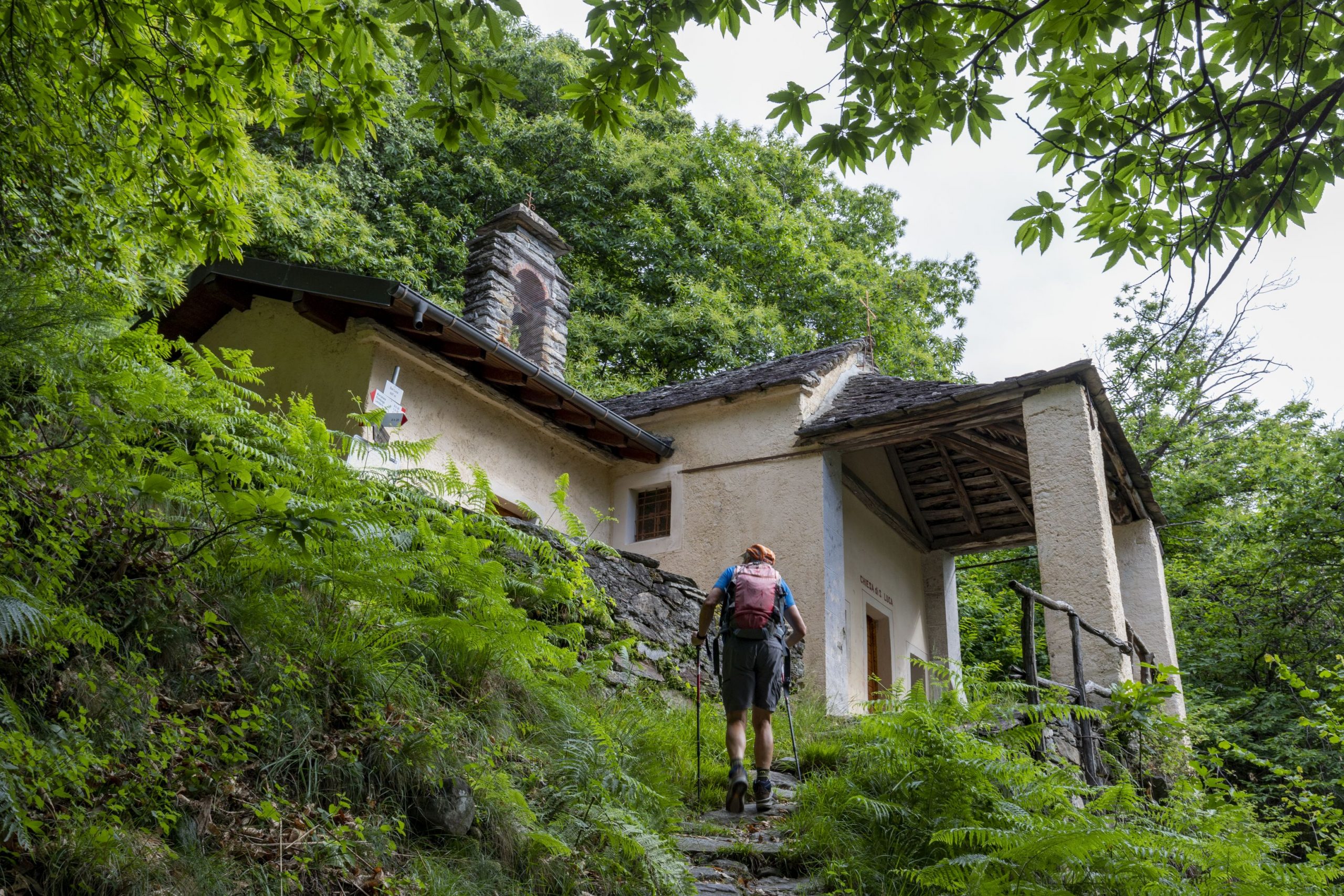
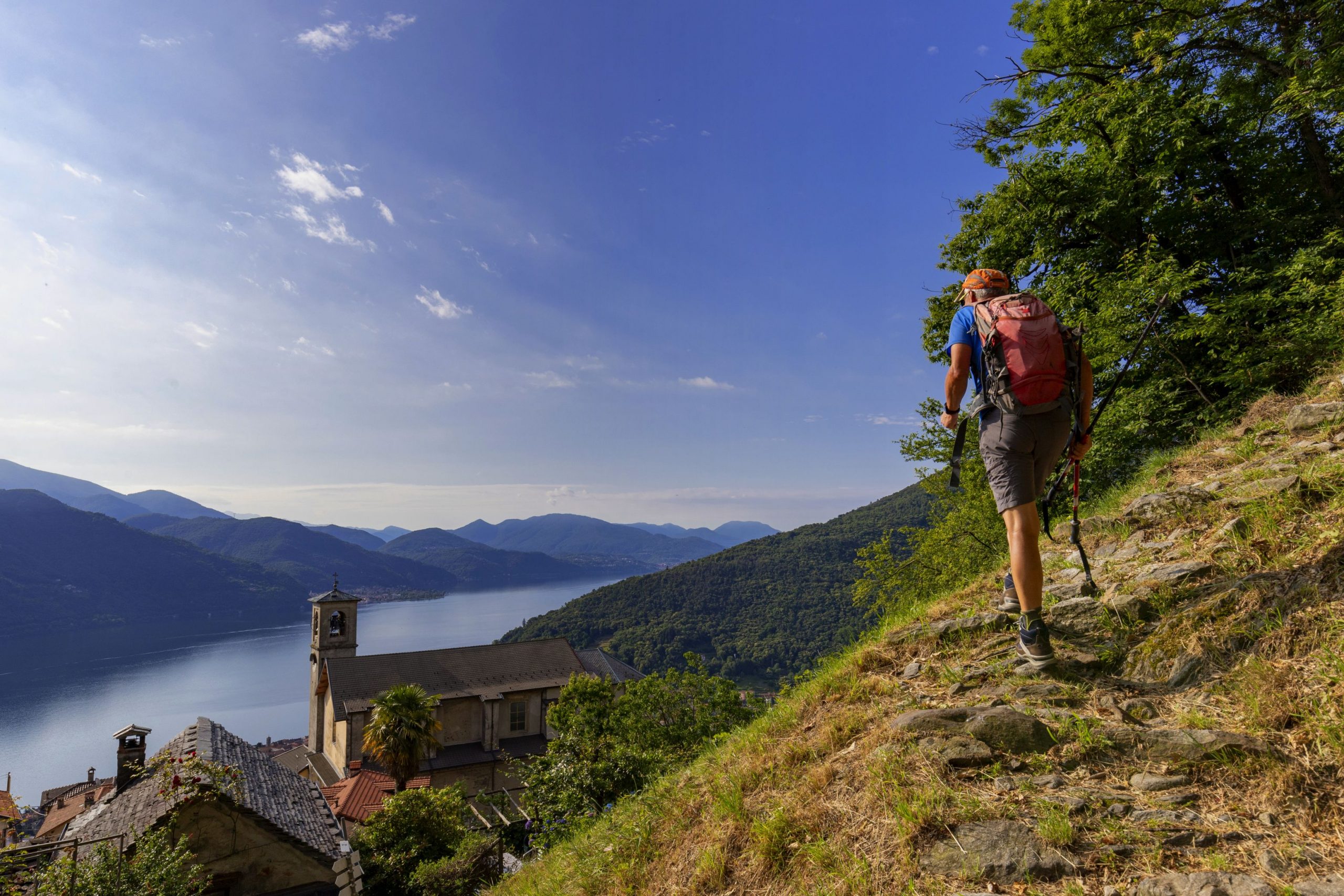
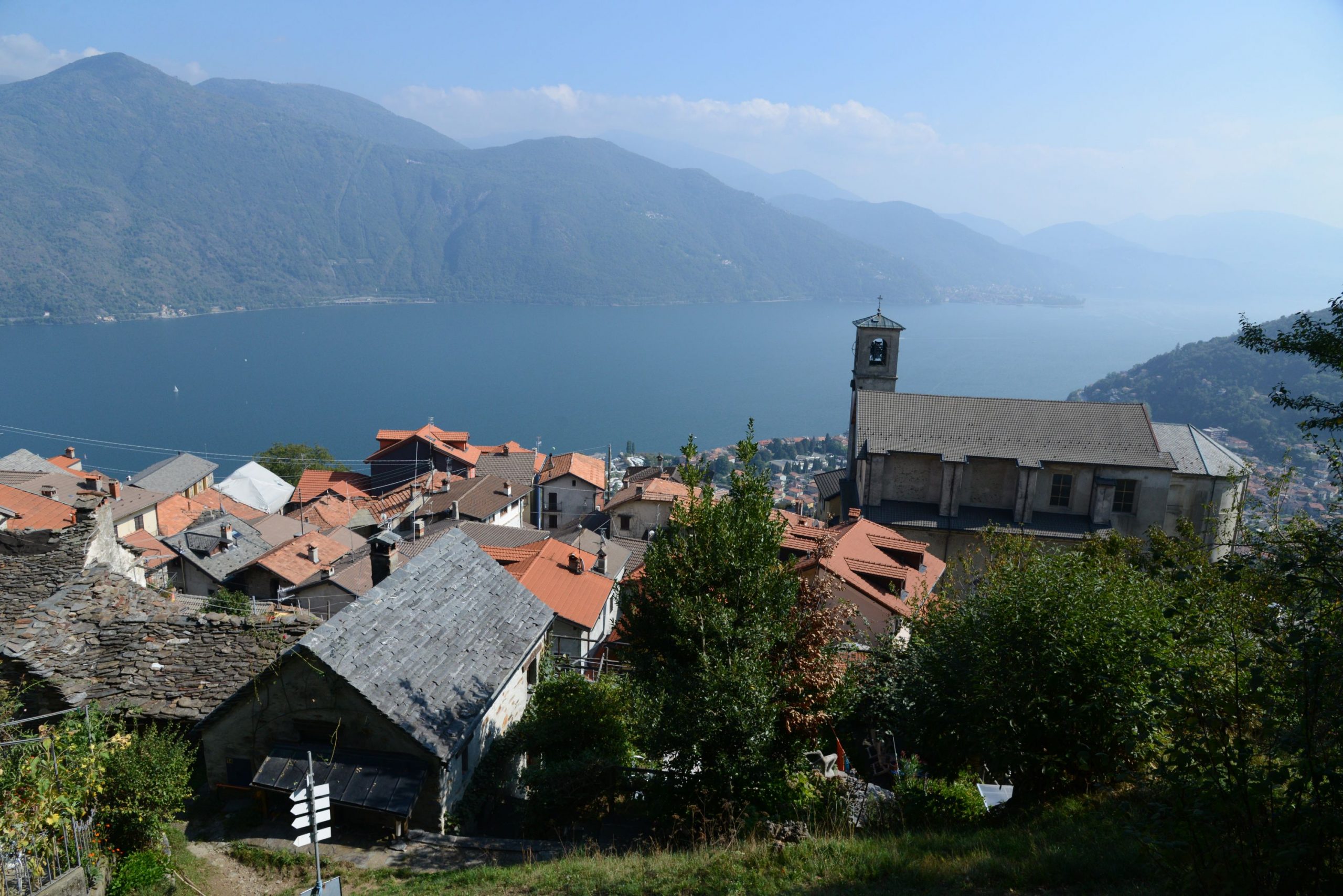
Das Dorf Sant’Agata liegt oberhalb der Ortschaft Cannobio, wo sich bereits ein schöner Blick über den See eröffnet. Beim Parkplatz nimmt man den Fußweg, der am Ende mit einer Schranke verschlossen ist (blaues Fußgängerschild „strada privata“ und rot-weiße Zeichen) in Richtung eines Feldwegs, der dann zu einem Wanderweg wird, und an einer Grundschule vorbei auf die asphaltierte Straße führt. Man geht auf die Kirche zu, die man bereits sehen kann, und kommt zu einem wundervollen großen Balkon über dem See (Brunnen, WC und Bar). Man geht am religiösen Gebäude vorbei, unter einem Bogen durch und weiter durch das Labyrinth der Dorfgassen, wobei man den weiß-roten Punkten folgt, bis die Häuser enden und ein Weg nach rechts ansteigt (Schild „Monte Giove“). Es geht ein Stück zwischen Kastanienbäume und Eichen ziemlich steil bergauf, bis zu der kleinen Kirche S. Luca (687 m), mitten im Wald. Man wandert dann nach links nicht ganz so steil weiter bergauf durch ein schönes terrassiertes Gebiet, auf dem ab und zu einige Ruinen erscheinen. Kurz nach den Resten einer Ortschaft kommt man zu einer Abzweigung nach rechts (Schild „Monte Giove“), die man einschlägt.
Anmerkung: Achten Sie auf diese Stelle, auf dem Rundweg kommt man hier wieder zurück.
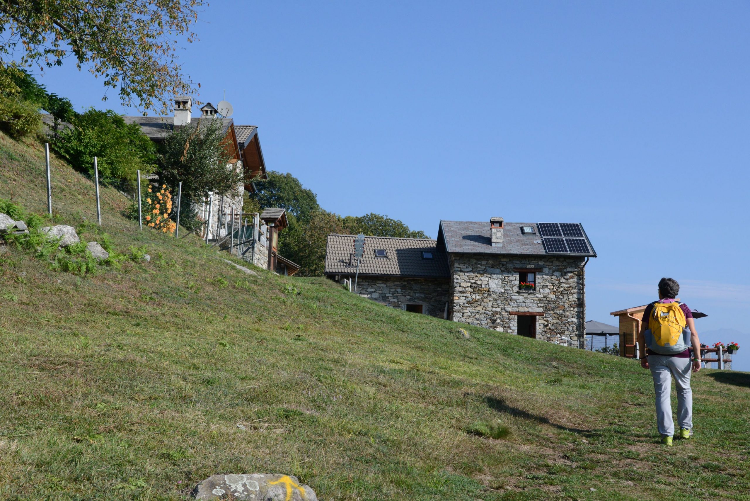
Nun geht es wieder in den Wald bis zu einer asphaltierten Straße, dieser folgt man nach links bergauf, um sie dann fast sofort wieder zu verlassen und auf einem Wanderweg links weiter bis nach Marcalone (860 m) zu gehen. Von diesem Dorf aus, das mit seinen Spielwiesen und einem Ferien-Bauernhof schon selbst ein Ausflugsziel sein kann, hat man einen wundervollen Blick auf den See.
Anmerkung: man kann auch mit dem Wagen bis hierher fahren, allerdings ist die Straße sehr schmal.
Sobald man die Wohnhäuser erreicht hat, geht es auf einer Treppe links („Monte Giove“) weiter, um dann das ganze Dorf zu durchqueren. Man kommt an die asphaltierte Straße, die man überquert, um den Wanderweg (Schild „Monte Giove“) einzuschlagen. Wenig später kommt man zu einer Gabelung mit weiß-roten Markierungen an beiden Pfaden, der breitere rechte Weg ist besser mit neueren Wegweisern. Der Wald besteht nun aus dicht aneinander stehenden Fichten. Wenn man die asphaltierte Straße erreicht hat, folgt man ihr nach rechts weiter bergauf und kommt zu einer ersten Abzweigung rechts, die eine große Kurve abkürzt (man braucht ihr aber nicht zu folgen), dann geht ein zweiter Weg links ab, der wieder eine kleine Abkürzung ist. Den dritten Wanderweg, der von der asphaltierten Straße nach rechts abzweigt, muss man aber einschlagen, da er die Straße ein großes Stück abkürzt, auch wenn es über einen steilen Anstieg zwischen Fichten bergauf geht (gut auf die weiß-roten Punkte achten, da man hier leicht vom Weg abkommen kann). Man stößt dann wieder auf die Straße, die hier in einen Waldweg übergeht und folgt diesem nach rechts, weiter bergauf, wobei sich die Vegetation ändert und zwischen Birken lichter wird. Nun erreicht man eine Gabelung zischen dem Waldweg und einem Wanderweg nach rechts, beide sind mit „Monte Giove“ beschildert.
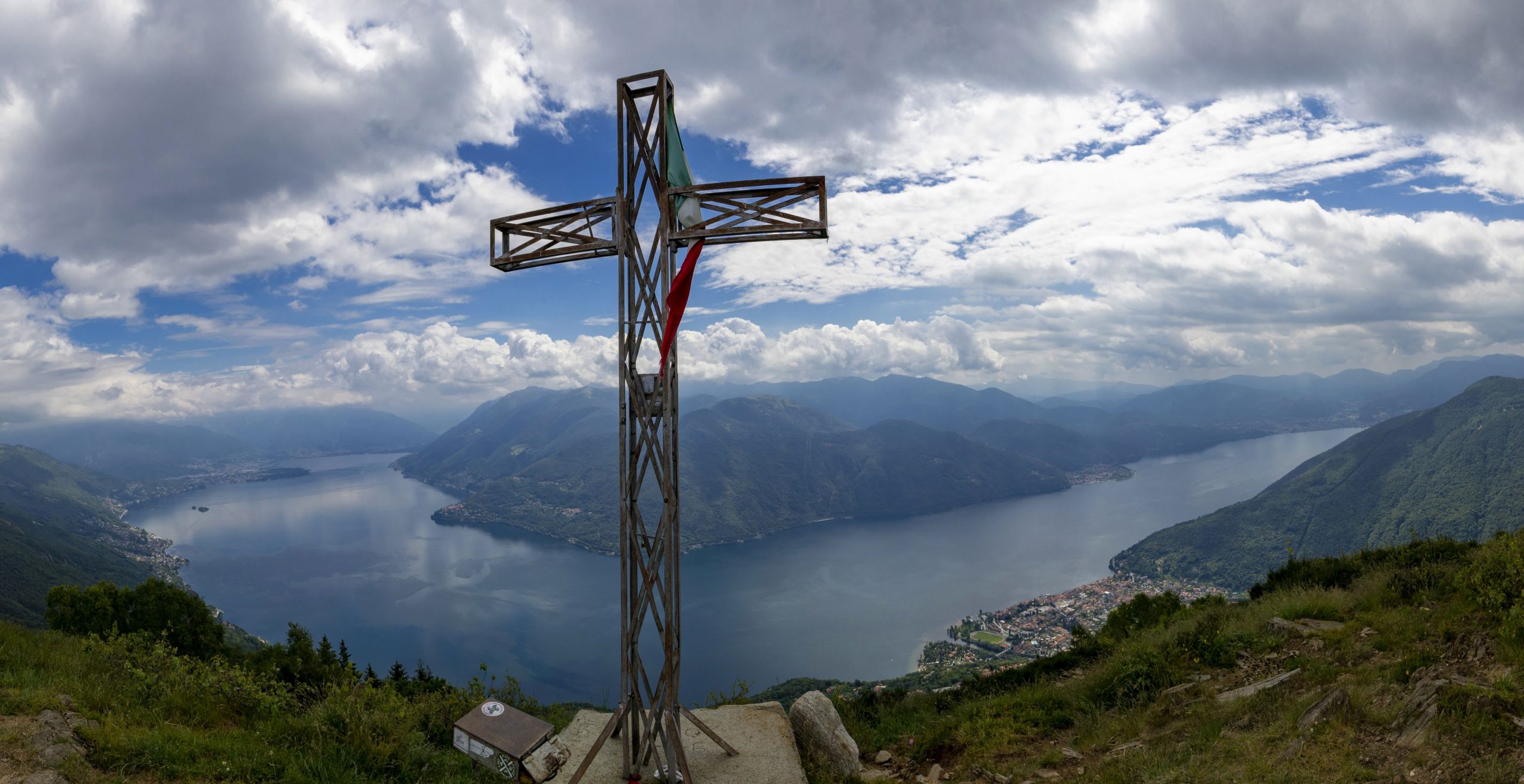
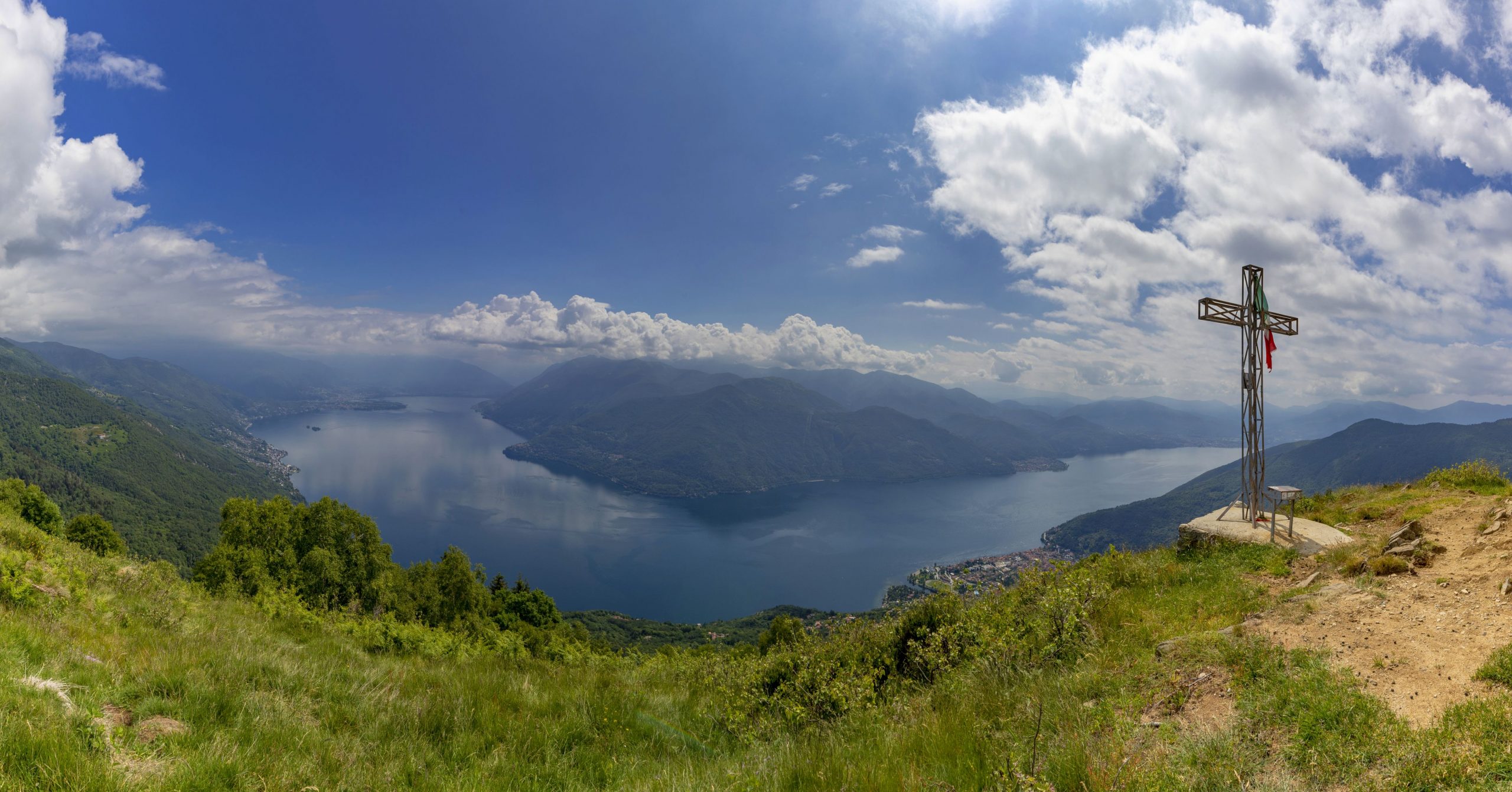
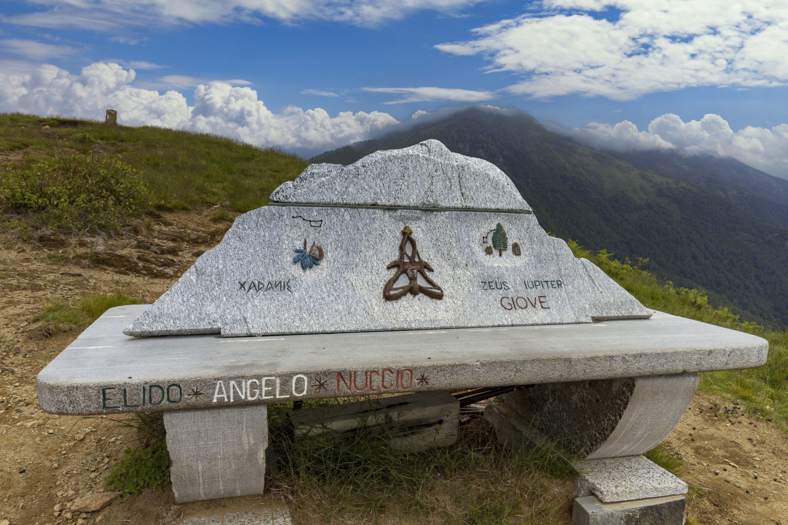
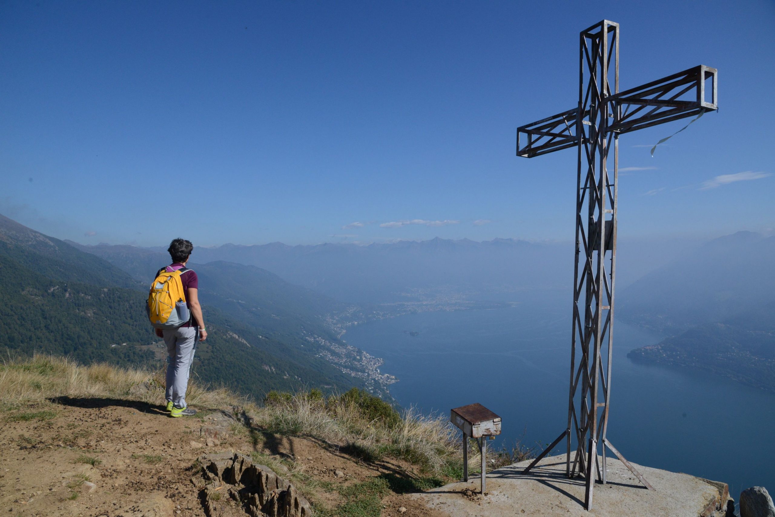
Beide Wege sind richtig, wir empfehlen aber den Waldweg, da der Wanderweg – zur Zeit der Ortsbegehung– schlecht war; außerdem geht es über den Waldweg auf einem richtigen Rundweg weiter. Man folgt also auf dem Waldweg, der langsam ansteigt, bis man nach einer Serpentine einen Wanderweg nach links (Holzschild) einschlägt. Die Landschaft öffnet sich auf diesem letzten Anstieg und gibt das Panorama frei, bis man den Gipfel mit Kreuz erreicht, wo eine künstlerische Bank den Varianten des Namens Jupiter („Giove“) gewidmet ist. Nachdem man den 360° Rundblick ausgiebig bewundert hat, geht es auf einer breiten Graspiste auf der anderen Seite hinunter. Die Piste wird schnell zu einem Wanderweg, der zwischen zunächst zwergwüchsigen dann immer größeren Birken mit Unterwald aus Farn steil bergab führt. Man kommt schließlich auf einen Waldweg, dem man nach links folgen muss und erreicht leicht abwärts gehend eine Kreuzung. Man wendet sich nach links zu den Tischen (Schild „Biessen“) und geht auf einem Feldweg weiter, der zum Dorf Rombiago (1167m) führt, kurz vor dem Ort nimmt man einen Wanderweg nach links (Schilder „Biessen“). Achtung, das nächste Stück ist nicht gut erkennbar, man kann leicht den falschen Weg nehmen: man darf nicht parallel zum Dorf gehen, sondern bergab durch den Birkenwald, um dann auf einen Wanderweg nach links zu stoßen (altes Schild „Biessen“). Hier geht es im dauernden Abstieg, der mit alten gelb-roten Schildern gekennzeichnet ist, im weiter bergab, erst durch Birkenhaine, dann durch Kastanien- und Eichenwald. Kurz nach einer kleinen Häusergruppe kommt man zu einer Gabelung, an der man nach links gehen muss (Schild „Sant’Agata“). Der Wanderweg ist lang aber gemächlich, nach einem einzelnen Bildstock kommt ein ziemlich exponiertes aber ungefährliches Stück, senkrecht über dem Cannobina-Tal.
Anmerkung: hier kann man rechts unten die Kirche Sant’Anna aus dem 17. Jh. sehen; sie liegt über einer vom Wasser eingeschnittenen Schlucht, die man auf einer kleinen mittelalterlichen Brücke überquert.
Der Wanderweg geht weiter gemächlich bergab zu den Überresten des Dorfes, an denen man schon auf dem Hinweg vorbeigekommen ist, von hier aus geht es bergab zurück zu der Kapelle S. Luca und dann steil abwärts bis zum Ausgangsort Sant’Agata.
Ratschläge zum Wandern mit Kindern
Dieser Ausflug ist recht lang, wegen der schönen Landschaften jedoch unbedingt empfehlenswert, aber nur für ältere oder an das Wandern gewöhnte Kinder geeignet.
Ausarbeitung der Strecke: Franco Voglino, Annalisa Porporato und Nora Voglino
Texte: Franco Voglino und Annalisa Porporato
Zurück zur Routenliste

A challenging semi-circular excursion that leads through dense woods and charming abandoned villages
CANNOBIO – MONTE GIOVE
Lago Maggiore
Routenbeschreibung
Departure location: Sant’Agata di Cannobio (450 m)
Place of arrival: Monte Giove (1298 m)
Difference in altitude: 850 m total
Distance: 9 km total
Walking time not counting stops: 4 hours and 30 minutes total
Type of route: mixed (trail, asphalt, dirt road)
Signs: red/white “Monte Giove” signs; red/white marks; signs for “Biessen” and “Sant’Agata”; old yellow/red marks
Water: fountains in Sant’Agata
Recommended period: all year round, without snow
How to get there: the trail starting point is in a village located 38 km from Gravellona Toce. SS34 towards Verbania/Locarno. After the village of Cannobio, turn left towards Ronco and Sant’Agata. A large car park is on the left just before the village. By bus: line 17 Cannobio-Sant’Agata (www.vcotrasporti.it).
Information: Distretto Turistico dei Laghi www.distrettolaghi.it; IAT Office – Largo alla Chiesa 3 c/o Palazzo Parasio, Cannobio, www.procannobio.it; Municipality of Cannobio www.comune.cannobio.vb.it
the itinerary
The village of Sant’Agata overlooks the village of Cannobio, and gives excursionists a beautiful view of the lake before they even begin walking. From the car park, take the pedestrian road at the end that is closed by a barrier (a blue pedestrian sign says “strada privata” (private road) and there are red/white marks). It leads towards a grassy track and then a path that passes the elementary school to get to a paved road. Go towards the church, which you will be able to see, and you will come to a magnificent balcony overlooking the lake (with a water fountain, rest rooms and a coffee shop). Pass in front of the church and walk under the arch. Continue through the maze of alleys in the village, following the round red and white marks until you reach the end of the buildings where you’ll take the path uphill on the right (sign for “Monte Giove”). A rather steep climb through chestnut and oak trees takes you quickly to the small chapel of S. Luca (687 m) immersed in the woods. Continue to the left. The path is still climbing, but now a little more gradually, as it leads into a beautiful terraced area where ruins appear at times. Just after the remains of a village, you’ll get to a fork. Bear to the right and follow the sign for “Monte Giove”.
Note: Remember this spot because this is where the circular path ends up on the return trip.
Continue uphill again through the woods until you reach a paved road. Take this road to the left, uphill, but almost immediately you’ll leave the asphalt and take another path on the left that leads to Marcalone (860 m). This village has a marvellous view of the lake, and it can be considered a destination in its own right because it offers meadows where you can play and an agritourism business.
Note: you could also drive up to this location, but keep in mind that the road is quite narrow.
When you reach the houses, take the left staircase (“Monte Giove”) that leads through the entire village. When you get to the asphalt, cross it and take the path (sign for “Monte Giove”). A little further on, there is a fork in the path, with red and white markings on both paths. It’s best to keep right and stay on the widest path with the most recent rectangular signs.
The forest is now made up of thick spruce trees. When you reach the asphalt road, follow it uphill to the right. You’ll come to the first of three paths leading off the road to the right, which makes a short curve (but is not worth following). The second path goes to the left but will not save you much time. Take the third path leading off the asphalt to the right because it shortens the road a lot, even though it takes you up a steep climb through the spruces (pay close attention to the round red and white marks because it is easy to get on the wrong path). When you are back on the asphalt road – which at this point will turn into a dirt road – continue to the right, always uphill, and watch the vegetation change and open up amid the birches. You’ll come to a fork between the dirt road and a path to the right, both with signs for “Monte Giove”.
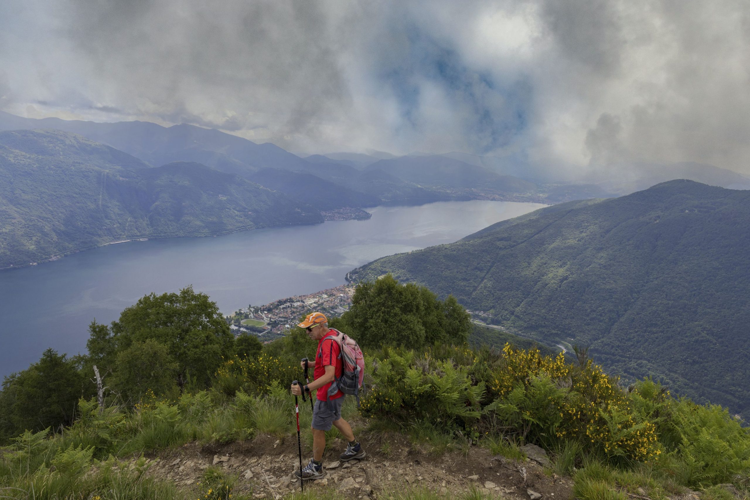
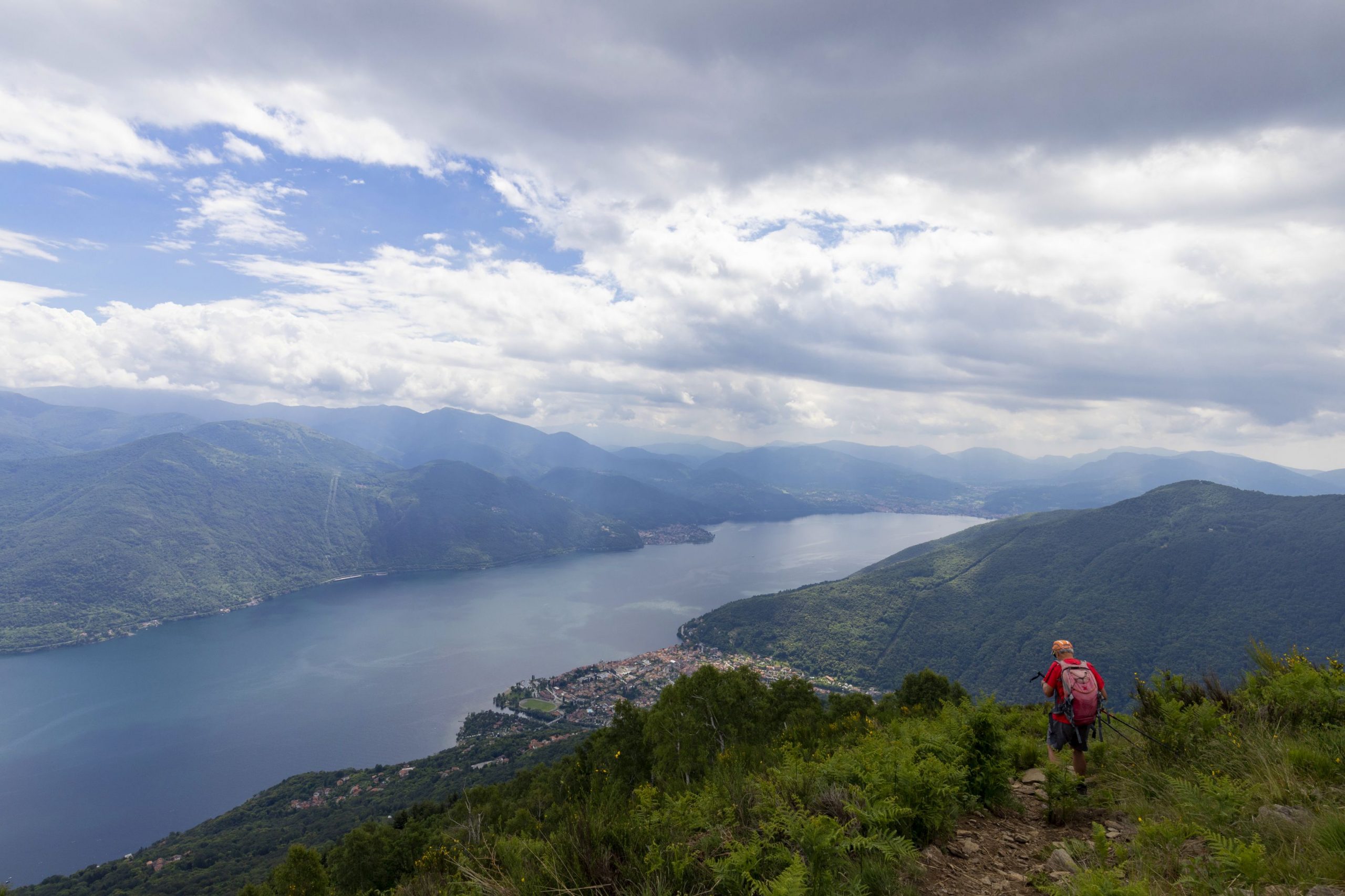
Both directions are correct, but we suggest you stay on the road because – at the time of our inspection – the path was not in very good shape. Also, staying on the road ensures a circular route. The dirt road climbs gradually and then makes a hairpin bend. Take the path on the left (wooden sign) and start up the last climb. Now, you are in an open panoramic environment, on a path that leads to the peak, where you will find a cross and an artistic bench dedicated to variants of the name Jupiter (Giove). After admiring the full 360° view, hikers can start down the wide grassy track on the opposite side of the hill with respect to where they came up. The track soon becomes a rapidly descending path amid short birches that then become increasingly large with beautiful ferns growing underneath. You will come out on a dirt road, and you must go to the left on a light downhill incline until you reach a crossroads. Turn left in the direction of the tables (sign for “Biessen”) along the grassy road that goes to the village of Rombiago (1167 m). Just before getting there, you’ll descend along the path on the left (signs for “Biessen”).
Be careful because this part of the path is hard to see and it is easy to get on the wrong track: do not walk parallel to the village, but instead go down through the birches and then you’ll find the path to the left (old sign for “Biessen”). The descent will be continuous and constant, indicated by old yellow-red marks, first among the birches and then amid the chestnuts and oaks. When you come to a small group of houses, and you will find a fork in the road. Go to the left (sign for “Sant’Agata”). The path winds along gradually. After an isolated votive pillar, it is rather exposed – there is sheer drop over the Cannobina Valley below – but it is not dangerous.
Note: if you look down to the right you can see the seventeenth-century Church of St. Anne positioned on a gorge dug by water, spanned by a small medieval bridge.
The path continues in a gradual descent, and leads to the ruins of the village you saw on your way up. From here, follow the downhill trail to the chapel of S. Luca and then continue the steep descent to return to the starting village, Sant’Agata.
tips for young hikers
A long excursion, this hike is absolutely recommended for its beautiful scenery, but it is only suitable for older children who are already accustomed to walking.
Trail creators: Franco Voglino, Annalisa Porporato and Nora Voglino
Content authors: Franco Voglino and Annalisa Porporato
Zurück zur Routenliste
Escursione impegnativa semicircolare che porta attraverso fitti boschi e suggestive borgate abbandonate
CANNOBIO – MONTE GIOVE
Lago Maggiore
Routenbeschreibung
Escursione impegnativa semicircolare che porta attraverso fitti boschi e suggestive borgate abbandonate ad una balconata a 360° sulla parte settentrionale del Lago Maggiore e sulla Valle Cannobina.
località di partenza: Sant’Agata di Cannobio (450 m)
località di arrivo: Monte Giove (1298 m)
dislivello: 850 m totali
distanza: 9 km totali
tempo di percorrenza al netto delle soste: 4 ore e 30 minuti totali
tipologia di percorso: misto (sentiero, asfalto, sterrata)
segnaletica: cartelli bianco/rossi “Monte Giove”; segni bianco/rossi; cartelli “Biessen” e “Sant’Agata”; vecchi segni giallo/rossi
acqua: fontane in Sant’Agata
periodo consigliato: tutto l’anno in assenza di neve
come arrivare: il borgo di partenza dista 38 km da Gravellona Toce. SS34 direzione Verbania/Locarno. Superato il centro abitato di Cannobio si devia a sinistra in direzione Ronco e Sant’Agata. Ampio parcheggio sulla sinistra appena prima della borgata. In autobus: linea 17 Cannobio-Sant’Agata (www.vcotrasporti.it).
informazioni: Distretto Turistico dei Laghi www.distrettolaghi.it; Ufficio IAT – Largo alla Chiesa 3 c/o Palazzo Parasio, Cannobio, www.procannobio.it; Comune di Cannobio www.comune.cannobio.vb.it
L’itinerario
La borgata di Sant’Agata sovrasta l’abitato di Cannobio, aprendo già una bella visuale sul lago.
Dal parcheggio si prende la strada pedonale al termine, chiusa da una sbarra (cartello blu pedonale “strada privata” e tracce rosso/bianche), verso una pista erbosa e poi un sentiero che, passando accanto alla scuola elementare, porta sulla strada asfaltata. Si va verso la chiesa, già a vista, arrivando ad una magnifica balconata sul lago (fontana, wc e bar).
Passando davanti all’edificio sacro si cammina al di sotto dell’arco proseguendo poi nel dedalo di vicoletti della borgata, seguendo i bolli bianco/rossi fino ad arrivare al termine degli edifici dove si prende il sentiero in salita a destra (cartello “Monte Giove”). Si affronta un tratto di salita piuttosto ripida tra castagni e querce, che porta rapidamente alla Chiesetta di S. Luca (687 m) immersa nel bosco. Si continua verso sinistra, ancora in salita ora un poco più graduale, inoltrandosi in una bella zona terrazzata in cui appaiono a tratti alcuni ruderi. Proprio dopo i resti di una borgata si arriva ad un bivio che va preso verso destra (cartello “Monte Giove”).
Nota: tenete a mente questo punto poiché è qui che si chiuderà il cerchio del ritorno.
Si prosegue nuovamente in salita nel bosco fino ad arrivare ad una strada asfaltata, si prende questa a sinistra, in salita, per abbandonarla quasi subito imboccando un sentiero sulla sinistra che porta a Marcalone (860 m).
Meravigliosa la vista sul lago che si ha da questo villaggio, che può essere anche considerato una meta a sé poiché offre prati dove giocare e un agriturismo.
Nota: fin qui si potrebbe anche arrivare in auto ma si tenga presente che la strada è parecchio stretta.
Giunti nei pressi delle abitazioni si prende la scalinata a sinistra (“Monte Giove”) che porta ad attraversare tutta la borgata. Toccato l’asfalto, lo si attraversa per imboccare il sentiero (cartello “Monte Giove”). Poco oltre si trova un bivio, con segno bianco-rosso su entrambe le tracce, meglio tenersi a destra sul sentiero più largo con le tacche più recenti.
Il bosco ora è formato da fitti abeti rossi. Giunti su strada asfaltata, la si segue verso destra sempre in salita, si passa davanti ad un primo sentiero che si stacca a destra e taglia una breve curva (non vale la pena seguirlo), poi un secondo sentiero verso sinistra che di nuovo fa risparmiare poco.
Il terzo sentiero che si stacca dall’asfalto verso destra va invece preso perché accorcia di molto la strada anche se si affronta una ripida salita tra gli abeti (prestate molta attenzione ai bolli bianco-rossi perché è facile imboccare una traccia diversa). Si torna di nuovo sulla strada, che in questo punto passa da asfalto a sterrato, proseguendo verso destra, sempre in salita, mentre la vegetazione cambia aprendosi tra le betulle. Si arriva ad un bivio tra sterrata e un sentiero verso destra, entrambi con cartelli “Monte Giove”.
Ambo le direzioni sono corrette ma suggeriamo di proseguire sulla strada poiché – all’epoca del sopralluogo – il sentiero era poco agevole; inoltre, percorrendo la strada si effettua un vero e proprio giro circolare.
Si percorre dunque la sterrata che sale graduale fino a superare un tornante, poi si prende il sentiero a sinistra (cartello di legno) affrontando l’ultima salita che ora, in ambiente aperto e panoramico, porta alla cima caratterizzata da una croce e una panchina artistica dedicata alle varianti del nome Giove. Ammirata la vista a 360°, si scende lungo l’ampia pista erbosa dalla parte opposta del sentiero da cui si è giunti. La pista diventa presto sentiero in rapida discesa tra betulle inizialmente nane poi sempre più grandi con bel sottobosco a felci. Si sbuca su una strada sterrata che va presa verso sinistra in leggera discesa fino ad arrivare ad un incrocio. Si prende a sinistra in direzione dei tavolini (cartello “Biessen”) percorrendo la strada inerbita che raggiunge la borgata di Rombiago (1167 m), appena prima della quale si scende lungo il sentiero a sinistra (cartelli “Biessen”).
Attenzione, il tratto seguente non è molto evidente, è facile prendere la traccia sbagliata: non ci si deve tenere paralleli alla borgata ma scendere attraverso le betulle per poi trovare il sentiero verso sinistra (vecchio cartello “Biessen”). Si affronta una discesa continua e costante, segnata da vecchi segni giallo-rossi, prima tra betulle poi tra castagni e querce.
Raggiunto un piccolo nucleo di case, si trova un bivio che va preso verso sinistra (cartello “Sant’Agata”). Il sentiero si snoda lungo ma graduale, dopo un isolato pilone votivo è alquanto esposto a picco sulla sottostante Valle Cannobina, ma non pericoloso.
Nota: se si guarda in basso verso destra si vede la seicentesca Chiesa di Sant’Anna posizionata su di un orrido scavato dalle acque e attraversabile con un piccolo ponte medievale.
Il sentiero, sempre in discesa graduale, porta ai ruderi della borgata già incontrata in salita, da qui si segue la discesa fino alla cappella di S. Luca per poi scendere in modo ripido fino a tornare alla borgata di partenza, Sant’Agata.
consigli per i baby escursionisti
Escursione parecchio lunga, consigliatissima per la bellezza dei paesaggi, ma adatta solo a bambini più grandi e comunque abituati a camminare.
Realizzatori del percorso: Franco Voglino, Annalisa Porporato e Nora Voglino
Autori dei testi: Franco Voglino e Annalisa Porporato
Zurück zur Routenliste

